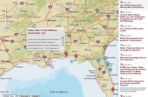
I’m taking this opportunity to feature a nice mapping technology that should interest politicians, campaign managers and their fanatical supporters anywhere in the world. So far, I haven’t seen such technology being used by politicians on my part of the world but the technology is already quite common in the US. How do the online maps look like? How does it work? Read on to find out.
Online Maps for Politicians, Campaign Managers and their Fanatical Supporters!
Alright, let’s take a look at some great online interactive map examples currently used by US senators such as Scott Brown, Jerry Moran and Marco Rubio.

I’m sure by now you have noticed that their online interactive maps more or less look the same. There’s a reason for that. It is because their online interactive maps are all powered by the same content management system (CMS). Their CMS is called HillTop and it is developed by GSL Solutions with a little help from Esri’s incredibly powerful ArcGIS JavaScript API.
Let’s leave the technical jargons behind and think about the things politicians and their campaign managers can do with this nice looking online mapping technology. As far as I’m concerned, it has limitless potentials! Let me just give you a few good examples. Politicians can put their calendars on such maps and let their constituents or supporters know when they’re in the neighborhood and easily-reached politicians get the winning votes. ;) Campaign managers on the other hand, can also use such maps to track and monitor their campaigns. One quick look at the map and campaign managers can identify towns and cities that are yet to be covered.
Forward this to your favorite politicians and let them know that such technology is now available. Do it today!


0 comments:
Post a Comment