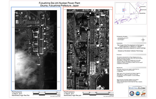
A team of researchers at RIT (Rochester Institute of Technology) are currently in the process of producing high-resolution imagery maps in friendly PDF documents from satellite images of areas in Japan that were recently hit with a big 9.0 earthquake and tsunami. What can those hi-res maps tell us? Read on to find out.
High-Resolution Imagery Maps of Fukushima Nuclear Power Plant, Hachinohe and Kesennuma! Courtesy of RIT
I should also add that RIT’s high-resolution imagery maps include before-and-after images that can help experts determine the extent of damage and destruction caused by the recent 9.0 magnitude earthquake and tsunami. Digital Globe’s WorldView-1, WorldView-2 and GeoEye’s GeoEye-1 images were used by the RIT researchers to produce their high-resolution imagery maps. So far they have uploaded 30 megabytes of PDF documents to the USGS site. As one of the members of the International Charter of Space and Major Disasters, USGS will share the high-imagery maps with other charter members and the Japanese authorities.


0 comments:
Post a Comment